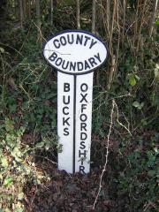
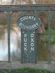
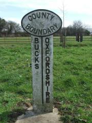
Fa : Map Reference SU 7423 8607
Fawley parish. On an unclassified road between Fawley Bottom, Buckinghamshire, and Middle Assendon, Oxfordshire, on the east side of the road. Legend BUCKS-OXFORDSHIRE. Photo: J.Nicholls, February 2008.
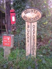
Tv1 : Map Reference SU 7378 8981
Turville parish (1). At Balham's Farm, on an unclassified road north of Stonor, on the south side of the road. Legend BUCKS-OXFORDSHIRE. Photo: J.Nicholls, February 2008.
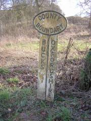
Tv2 : Map Reference SU 7282 9289
Turville parish (2). At Launder's Farm, on an unclassified road just west of Northend village, on the south side of the road. Legend BUCKS-OXFORDSHIRE. Photo: J.Nicholls, February 2008.
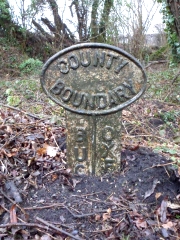
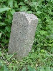
Bl : Map Reference SP 7695 0239
Bledlow parish. Between Bledlow, Buckinghamshire, and Chinnor, Oxfordshire, on the south side of the B4009. Legend BUC...-OXF... Photo: J.Nicholls, February 2012.
ThB : Map Reference SP 703- 065-
On Thame Bridge, taking what was a main road across the Thames north of Thame, now pedestrian only. A cast-iron 'lollipop'-style marker on the east side of the bridge. Legend BUCKS-OXON. Photo: D.Turner, November 2006.
IB : Map Reference SP 648- 064-
On Ickford Bridge, south of Ickford. Two stone plaques set into a parapet refuge, well carved but obscured by lichen. Legend 1: 1685 HERE ENDS THE COUNTY OF OXON. Legend 2: HERE BEGINETH THE COUNTY OF BUCKS 1685. Photo: J.Nicholls, February 2008. More
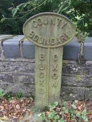
MG1 : Map Reference SP 6368 2007
Marsh Gibbon parish (1). On a bridge over the River Ray, just into a minor road running north from the A41 north of Piddington, on the east side of the road. Legend BUCKS-OXON. Photo: J.Nicholls, September 2007.
MG2 : Map Reference SP 6299 2353
Marsh Gibbon parish (2). On a bridge over a small stream on an unclassified road west of Marsh Gibbon, on the south side of the road. Legend BUCKS-OXON. Photo: J.Nicholls, September 2007.
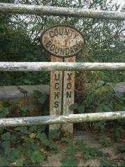
Ti : Map Reference SP 6400 3265
Tingewick parish. At the eastern end of Finmere village, north of the A421/A4421 roundabout. Legend BUCKS-OXFORDSHIRE. Photo: J.Nicholls, March 2008
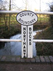
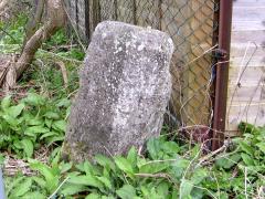
Tw : Map Reference SP 5996 3794
Turweston parish. On a bridge over the Great Ouse just north of Turweston village on the road to Brackley, on the north side of the bridge. A 'lollipop'-style marker but without back support. Legend NORTHANTS-BUCKS. Photo: J.Nicholls, January 2008.
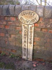
Bi : Map Reference SP 6316 4022
Biddlesden parish. On a bridge over a small stream on the road from Biddlesden, Buckinghamshire, to Syresham, Northamptonshire, on the east side of the bridge. A 'lollipop'-style marker but without back support. Legend NORTHANTS-BUCKS. Photo: J.Nicholls, January 2008.
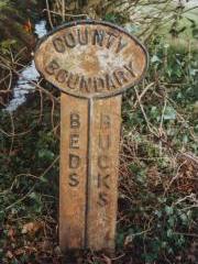
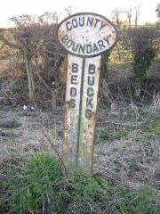
La : Map Reference SP 9344 5466
Lavendon parish. South of the entrance to Harrold Lodge Farm on the road from Lavendon, Buckinghamshire, to Harrold, Bedfordshire, on the east side of the road. Legend BEDS-BUCKS. Photo: M.Knight, June 2008.
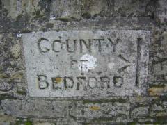
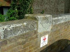
TuB : Map Reference SP 938- 524-
On Turvey Bridge, taking the A428 aross the Great Ouse, west of Turvey village. A stone plaque marking the Bedfordshire border, set into the south parapet. Legend COUNTY OF BEDFORD, with a sideways bench mark at the boundary. Photo: J.Nicholls, February 2008.
NC : Map Reference SP 9473 4395
North Crawley parish. At the entrance to Rings Wharley Farm on the road between East End Crawley, Bedfordshire, and North Crawley, Buckinghamshire, on the south side of the road. Legend BEDS-BUCKS. Photo: J.Nicholls, February 2008.
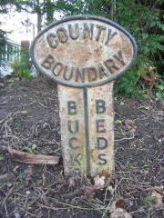
Wa : Map Reference SP 9306 3785
Wavendon parish. South of the M1 on the road between Woburn Sands, Buckinghamshire, and Salford, Bedfordshire. Legend BUCKS-BEDS. Photo: J.Nicholls, February 2008.
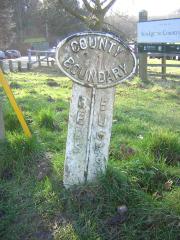
So : Map Reference SP 920- 294-
Soulbury parish. By the entrance to Stockgrove Country Park car park on Brickhill Road. Legend BEDS-BUCKS. Photo: J.Nicholls, February 2008.
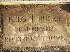
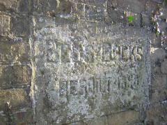
SB : Map Reference SP 932- 216-
On Slapton Bridge over the River Ouzel, north of Slapton village. A stone set into the east side walkway. Legend BEDS-BUCKS RESTORED 1881 RECONSTRUCTED 1990. Photo: J.Nicholls, February 2008.
EB : Map Reference SP 9648 2037
On Eaton Bridge over the River Ouzel, south-west of Eaton village. A stone plaque set into each parapet. Legend 1: BUCKS-BEDS REBUILT 1898. Legend 2: BEDS-BUCKS REBUILT 1898. Photo: J.Nicholls, February 2008.
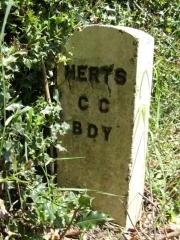
LG1 : Map Reference SP 9828 1428
Little Gaddesden parish (1). At Ringshall village on a minor road heading west past Ivinghoe Common. A recent concrete stone. Legend HERTS/CC/BDY. Photo: J.Nicholls, June 2008.
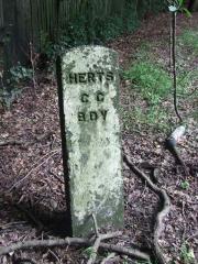
LG2 : Map Reference SP 978- 129-
Little Gaddesden parish (2). On the B4506 at Pitstone Common. A recent concrete stone. Legend HERTS/CC/BDY. Photo: J.Nicholls, February 2008.
Tr : Map Reference SP 8775 1766
Tring parish. South of Thistlebrook Farm on the road between Wingrave, Buckinghamshire, and Long Marston, Hertfordshire. A recent concrete stone. Legend HERTS/CC/BDY. Photo: J.Nicholls, June 2008.
DB : Map Reference SP 9098 1105
Drayton Beauchamp parish. On the north side of the B4365. A damaged and worn stone. Legend 1: COUNTY/ OF BUCKS/ DRAYTON/ BEAUCHAMP/ PARISH. Legend 2: COUNTY/ OF HERTS/ TRING/ PARISH. Photo: J.Nicholls, April 2010.
CB : Map Reference TQ 0279 7703
On Colnbrook Bridge, crossing the Colne Brook east of the village. A plaque on each parapet. Legend 1: MIDDX 1777 BUCKS. Legend 2: BUCKS 1777 MIDDX. Photo: J.Nicholls, June 2008.