|
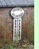 This site records the locations of all the surviving boundary markers I know about showing the limits of the county of Berkshire. It's the result of a survey undertaken between 2006 and 2009 of virtually all the roads crossing the border, though I can't guarantee to have found every survivor, especially where thick hedgerows verge the roadside. Still, it came as some surprise that as many as 21 are still around, the large majority (17) made of cast iron and of identical 'lollipop' form. They probably date from the 1930s, as there is evidence from a catalogue of this time that the Hub Ironworks of Chipping Norton manufactured boundary markers of exactly that type. Most now seem to have been forgotten about and are in a poor state of upkeep, though their sturdy nature means that they are likely to last a long time yet. On the other hand, a few have been damaged, presumably by vehicle impact.
The north-western end of the boundary shown on the map is at Lambourn Corner, where the post-1974 Berkshire border separates from the historical boundary, the new line setting off north and east while the old line goes west and north. It seemed optimistic to expect traditional boundary markers on the new border so I haven't looked there, and any remaining markers on the old line would misleadingly indicate Wiltshire/Berkshire instead of Wiltshire/Oxfordshire. Certainly the first half-dozen road crossings along the old boundary yielded no hits. The other end of the boundary shown is on the River Thames just south of the village of Moulsford, where the post-1974 boundary goes west and the historical boundary continues north along the river.
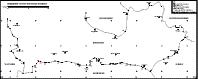
See the boundary marker map which acts as an index to the markers.
There are also images and locations of all the markers and information about them.
Or return to the Contents Page.
|
