|
 The old long-distance road route between Southampton, Oxford and Manchester largely became the A34 when road classifications were introduced, and is the subject of the Milestone Society's A34 Project. My itinerary maps cover the southern part, through the counties of Hampshire, Berkshire and Oxfordshire, aiming to highlight periods of major change in its history. Each map has an accompanying commentary.
Before the coming of the turnpikes, mainly in the 18th century, upkeep of the roads was the responsibility of the parish they passed through, and consequently they were often poorly surfaced and much complained-of. The turnpikes were a great improvement, though it was then the tolls that were unpopular.
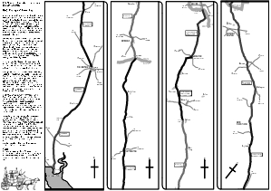
See the full-size map for 1800, the Age of Turnpikes.
See the full-size map for 1890. the Age of Railways.
See the full-size map for 1950, Return to the Roads.
See the full-size map for 2000, the Age of Bypasses.
Or return to the Contents Page.
|