|
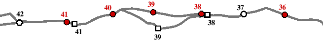
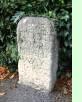 Two maps are available here, showing mile markers at different times. The historical map shows the location of all mile markers I have been able to find, surviving or not, within the 19th century boundaries of Oxfordshire. The condition map on the other hand shows the condition of currently surviving mile markers within the modern, enlarged, county. My thanks are due in particular to Derek Turner, the Milestone Society's Oxfordshire representative, for much help and encouragement in this enterprise. Also to Alan Rosevear, keeper of the great MSS database, which I have mercilessly plundered in all of my milestone maps.
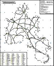
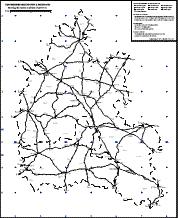
See the full historical map or the modern condition map
(note that these are large images and may take a few seconds to appear).
Or return to the contents page.
|